In Vaughan, geotechnical investigations must align with the National Building Code of Canada (NBCC) and Ontario Regulation 332/12, especially when working atop the complex deposits of the Oak Ridges Moraine. A seismic tomography survey, encompassing both refraction and reflection methods, is often the first line of investigation to decipher this subsurface puzzle. The technique provides continuous profiles of P-wave and S-wave velocities, helping engineers differentiate between dense till, saturated sand channels, and competent shale bedrock. Rather than relying on scattered borehole logs alone, our team integrates seismic tomography data to create a solid ground model, which is critical for high-rise foundations near the Vaughan Metropolitan Centre or for infrastructure corridors cutting through the Humber River valley. The method directly supports compliance with NBCC site classification requirements, particularly in assessing Site Class C, D, or E profiles before excavation begins.
Mapping the hidden velocity inversions within the Oak Ridges Moraine requires a combined refraction and reflection approach to avoid missing critical low-velocity zones.
Service characteristics in Vaughan
Local geotechnical conditions in Vaughan
At an elevation of approximately 200 meters above sea level, Vaughan's terrain varies from flat till plains to deeply incised river valleys, creating a dynamic groundwater regime that complicates any geophysical survey. Skipping a seismic tomography program in areas with buried bedrock valleys—common in the Humber and Don River corridors—can lead to misjudging pile lengths by several meters. The real danger lies in velocity inversions: a dense till layer overlying loose, saturated sand simply looks like continuous high-velocity ground to a basic refraction array. Without a dedicated reflection component, a designer might unknowingly place a footing on material susceptible to long-term settlement or even liquefaction under seismic loading. Given Vaughan's location in a moderate seismic hazard zone, per the 2020 NBCC seismic hazard maps, characterizing these low-velocity anomalies isn't just good practice—it's a direct requirement to avoid differential settlement in sensitive structures like data centers or cold storage facilities.
Our services
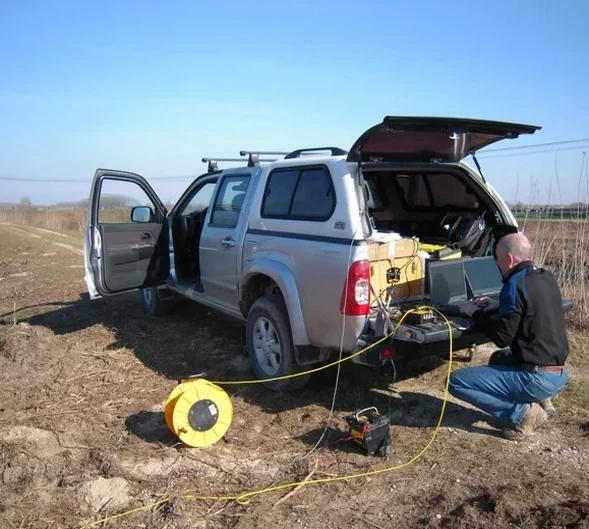
Our seismic tomography services in Vaughan are structured to address the specific challenges posed by the region's glacial geology and urban development pressures.
Combined Refraction & Reflection Tomography
A hybrid survey designed for the Oak Ridges Moraine. We deploy a long geophone spread and high-energy sources to simultaneously acquire first breaks for refraction analysis and stacked CMP gathers for shallow reflection processing. This dual approach is essential for identifying low-velocity layers and accurately mapping the overburden-bedrock interface beyond 30 meters depth.
Downhole & Crosshole Seismic Tomography
When a project already includes boreholes, we insert borehole geophones and hydrophones to generate high-resolution velocity tomograms between drillholes or from the surface downward. This method measures the true interval velocity of each distinct stratigraphic unit in Vaughan, providing a calibration benchmark for surface-based refraction profiles and improving the accuracy of Vs30 calculations for NBCC site classification.
Frequently asked questions
What is the cost of a seismic tomography survey in Vaughan?
A combined refraction and reflection seismic tomography survey on a standard lot in Vaughan typically ranges between CA$4,010 and CA$6,090. The final cost depends on the total length of the profile, the number of geophone channels required, and the accessibility of the site. Urban sites with extensive pavement or buried utilities may require additional preparation that influences the overall budget.
How does seismic tomography help with NBCC seismic site classification in Vaughan?
The NBCC requires a shear wave velocity (Vs) profile of the upper 30 meters to determine site class. Seismic refraction alone provides P-wave velocity. We use the combined refraction and MASW or reflection tomography approach to derive solid Vs30 values, directly enabling classification as Site C (very dense soil/soft rock) or Site D (stiff soil), which are the most common designations in Vaughan.
Can seismic reflection detect the bedrock surface beneath the Oak Ridges Moraine?
Absolutely. The acoustic impedance contrast between the dense Halton Till and the underlying Georgian Bay Shale generates a strong reflector. Our high-resolution reflection component is specifically configured to image this interface, even when the bedrock surface is highly irregular or dissected by buried valleys common in the Humber River watershed in Vaughan.
What is the difference between seismic refraction and reflection for geotechnical work in Vaughan?
Seismic refraction relies on critically refracted head waves traveling along velocity boundaries, which works well when velocities increase with depth. In Vaughan, where a stiff till may overlie soft saturated sands, this condition is violated. Seismic reflection records near-vertical reflections, independent of velocity inversions, allowing us to see the 'hidden' low-velocity layers that refraction misses. A combined survey mitigates the limitations of both methods. More info.