The thick glacial till and complex Paleozoic bedrock beneath Vaughan, combined with the city's position within the Oak Ridges Moraine, create a highly variable subsurface profile that directly influences how seismic waves propagate. Unlike regions with uniform rock near the surface, Vaughan's sediments can amplify ground motion, a phenomenon confirmed during the 2010 Central Canada earthquake, which was felt distinctly across York Region. Our seismic microzonation approach quantifies these local site effects by developing detailed shear-wave velocity profiles and assessing dynamic soil properties. We integrate this data with the MASW survey results to map fundamental site periods, and when deeper bedrock characterization is needed, the seismic refraction method helps delineate the soil-rock interface. The resulting maps provide engineers with the spectral acceleration values required by the 2020 National Building Code of Canada, moving beyond a simple default Site Class to a performance-based understanding of ground shaking.
Vaughan's variable glacial stratigraphy means two adjacent sites can have fundamentally different seismic responses, a nuance only captured by rigorous microzonation.
Service characteristics in Vaughan
Demonstration video
Local geotechnical conditions in Vaughan
With a population exceeding 320,000 and a concentration of high-density residential towers and major transportation corridors like Highway 400 and the forthcoming subway extension, Vaughan's exposure to even a moderate seismic event is significant. The primary risk is not necessarily structural collapse from shaking alone, but the amplification of long-period motion in deep soil pockets that could resonate with mid-rise buildings, coupled with the potential for seismically-induced settlements in loose, saturated sands found in buried channels. Ignoring site-specific response can lead to underestimating design loads by 30% or more, a gap that becomes critical in a city where infrastructure is expanding vertically and the subsoil conditions change over short distances. Our microzonation studies directly address this by providing the foundation input motions for advanced structural analysis.
Our services
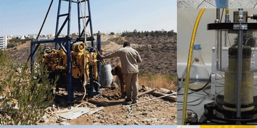
A complete seismic microzonation project in Vaughan integrates several specialized field and laboratory services to build a reliable ground model. The following services are typically combined to achieve the resolution required for regulatory compliance and design optimization.
Site-Specific Response Analysis
One-dimensional and two-dimensional equivalent linear or non-linear analyses using input rock motions scaled to the NBCC 2020 uniform hazard spectrum. We model the complete soil column to generate surface response spectra for each zone.
Geophysical Surveying & Vs Profiling
Execution of MASW, downhole, and crosshole seismic surveys to measure in-situ shear wave velocity. These profiles are correlated with borehole logs to define the stratigraphic boundaries that control wave propagation.
Dynamic Laboratory Testing
Resonant column and cyclic triaxial tests on representative soil samples to determine shear modulus degradation and damping curves specific to Vaughan's glacial and interglacial deposits.
Frequently asked questions
What is the typical cost range for a seismic microzonation study in Vaughan?
Depending on the size of the study area and the density of borehole and geophysical lines, a microzonation study in Vaughan typically ranges from CA$6,250 to CA$25,230. Smaller site-specific response analyses for a single building are at the lower end, while comprehensive mapping for a subdivision or industrial park falls at the higher end.
How does the NBCC 2020 classify Vaughan's seismic hazard?
The NBCC 2020 places Vaughan in a region of moderate seismic hazard. The code provides uniform hazard spectra for reference ground conditions (Site Class C). However, since Vaughan is dominated by softer glacial soils, an automatic Site Class D or E often applies, which requires detailed microzonation to avoid overly conservative or unconservative design forces.
Why is microzonation necessary if we already know the Site Class?
Site Class alone is a broad-brush approach based on average Vs30. In Vaughan's moraine landscape, deep pockets of soft clay and dense till can exist side-by-side, creating 2D basin effects that a simple Site Class cannot capture. Microzonation maps these spatial variations, preventing uniform application of a single design spectrum across a large site.
What geophysical methods do you use for a Vaughan microzonation?
We primarily use a combination of Multi-channel Analysis of Surface Waves (MASW) and seismic refraction to map the shear-wave velocity structure. These are calibrated with downhole seismic testing in boreholes to ensure the velocity models accurately reflect the depths to the competent bedrock beneath the Oak Ridges Moraine sediments.
Can microzonation help reduce construction costs?
The reference range for this service in Vaughan is CA$6.250 - CA$25.230. The final price depends on the project scope and volume.